David's Evening Forecast - Wintry mix likely overnight
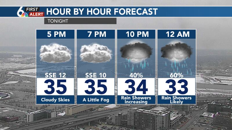
Parts of the metro managed a few glimpses of the sun this afternoon, but unfortunately it did not last long as clouds quickly thickened back up. Clouds and some light fog will persist through the rest of the evening as a weak storm system begins to approach. Rain showers will begin to spread in from the north and west after 9pm, with a few scattered rain showers likely by Midnight. After Midnight, we may see rain mix with or even change to some light snow showers through Friday morning. Temperatures will be near or above freezing, so little in the way of accumulation is expected.
A few scattered snow showers may be ongoing Friday morning, but will likely mix back to rain during the mid-morning hours, and come to an end before Noon. However clouds will be hanging around again for most of the day, keeping temperatures from moving much. Expect highs to once again top out in the middle 30s.
A welcomed warmer pattern will move in for the weekend. Sunshine will return on Saturday helping to boost high temperatures into the middle 40s. The warm up continues on Sunday, with highs climbing into the low or even middle 50s. That will likely lead to quite a bit of melting around the region. We will have to watch a few local rivers for the potential of ice jams as well.
Unfortunately, the warmer conditions don't last long. A cold front moves through on Monday dropping temperatures back into the 30s. Light snow appears more likely Monday night into Tuesday. Light accumulations may be possible for parts of the region with temperatures in the 20s. Temperatures drop into the teens Tuesday and Wednesday nights. Stay tuned for updates on this forecast.